Osoyoos evacuation order in effect as wildfire burns
Posted July 30, 2023 9:15 am.
Last Updated July 31, 2023 6:17 am.
An evacuation order has been issued by the Regional District of Okanagan-Similkameen and the Town of Osoyoos in southern British Columbia, upgrading an earlier alert issued due to a nearby wildfire.
Authorities say impacted residents should leave the area immediately.
Know the difference between an Evacuation Order and an Alert:
Evacuation Alert: be ready to leave on short notice.
Evacuation Order: leave the area immediately. https://t.co/Deapqay1CA
— Prepared BC (@PreparedBC) July 26, 2023
The order covers more than 700 properties in an area with boundaries west of Highway 97, south of Highway 3, east of Nighthawk Road, and north of the U.S. border.
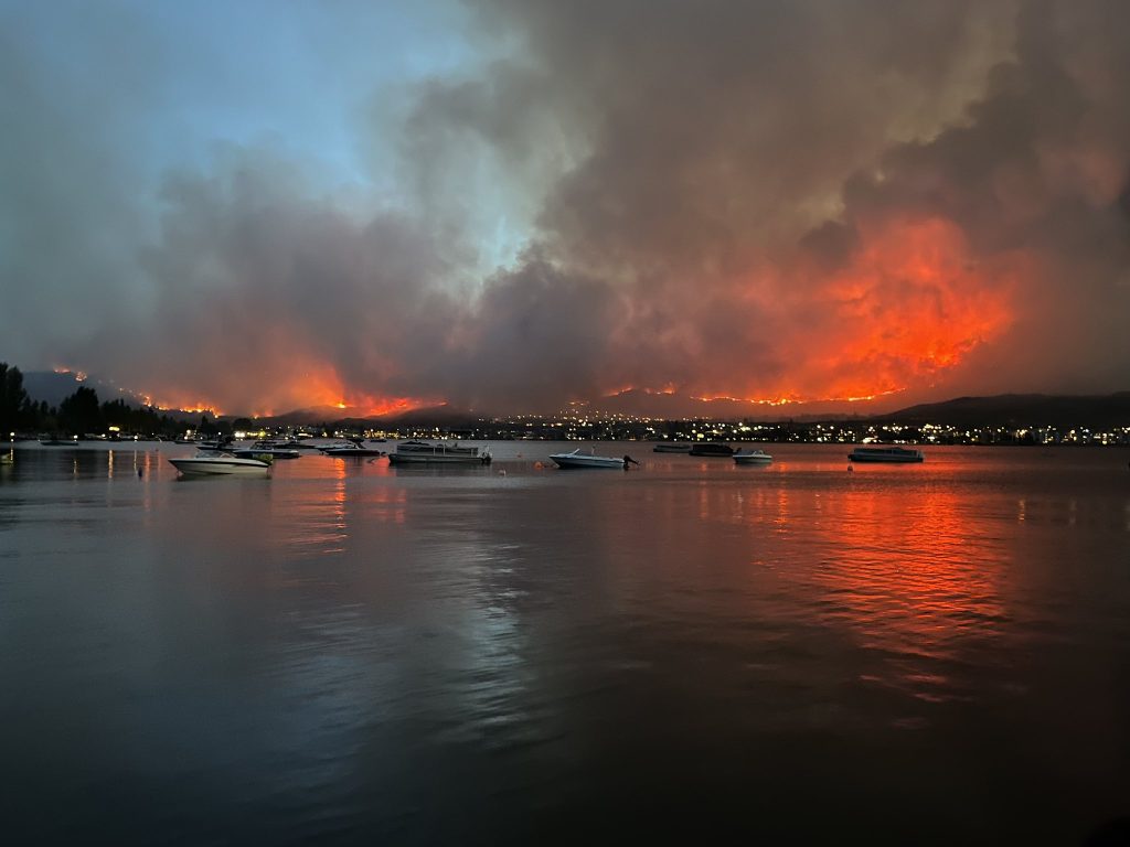
The speed of the #Osoyoos fire is what was most terrifying. Beautiful until 4pm we saw a cloud, 9pm it came over the hills and raced north towards town, 11pm were were on evac alert and the fire was burning right above us, and by 4am it seemed over pic.twitter.com/QShEBrsCLr
— Walter Wells (@WalterWellsRltr) July 30, 2023
After previously calling it the Lone Pine Creek wildfire, the BC Wildfire Service is now referring to the fire as the Eagle Bluff wildfire to align with the US Forest Service.
#Evacuation Alert issued for parts of @EmergMgtRDOS and Town of #Osoyoos. Anyone in the area should be ready to leave on short notice. More info: More info: https://t.co/bSyEAf13mv… #BCWildfire #Okanagan https://t.co/RiOiSUl0Su
— Emergency Info BC (@EmergencyInfoBC) July 30, 2023
The service says the fire is currently estimated to cover roughly 20 square kilometres on the U.S. side of the border, and two square kilometres on the Canadian side.
There have been 1,517 wildfires in British Columbia this year, burning 15,397 square kilometres of trees, bush and grassland.
At the parking of Pioneer Walkway here in Osoyoos, where the fire is growing exponentially SE. #BCWildfire pic.twitter.com/6OfrvnpILG
— Zachary C (@Zach_wx) July 30, 2023
Highway 3 is now closed between Keremeos and Osoyoos due to the fire.
DriveBC says a detour is in place, using Highway 3A to Highway 97.
In an update Sunday afternoon, Osoyoos Mayor Sue McKortoff says while she knew that the wildfire was in the United States, “it never occurred to me that it was going to come across the border.”
“But of course it did. And then it got a little bit scary because of the wind. It moved forward, moved north very quickly. And as soon as it got a little bit darker, you could really see all of the flames that were up there.
“It was pretty scary and it was moving very quickly,” McKortoff said.
The mayor says she’s been hearing from residents that the majority of evacuees have found places to stay.
“I’ve just heard people wanting to help and to volunteer,” she added.