Wildfires in B.C. causing evacuation alerts and orders
Posted September 10, 2022 3:02 pm.
Last Updated September 11, 2022 1:45 pm.
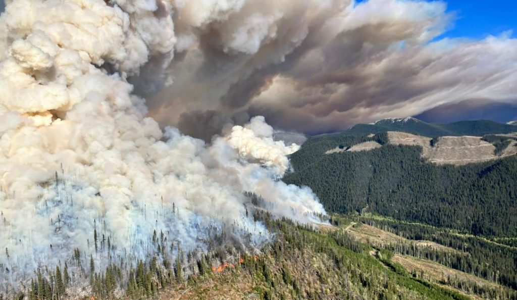
The Battleship Mountain wildfire is one of several fires blazing out of control in B.C.
The fire has now grown to over 17,000 hectares driven by “wind and extremely dry conditions.”
“Over the last 48 hours, the Battleship Mountain has displayed extremely aggressive fire behaviour and is [more than] 17,410 hectares in size,” said a BC Wildfire Service tweet.
“The extremely dry and windy conditions have driven fire behaviour to exhibit consistent Rank 5 with pockets of Rank 6.”
According to the BC Wildfire Service, Rank 6 is the highest ranked fire on the scale.

Photo credit: BC Wildfire Service
Due to the fire, an expanded evacuation order has been issued by the Peace River Regional District.
The order has been issued for the following areas:
- All of Twelve Mile Rd., Josef Rd., Dunlevy Rd., Eagle Heights Dr. and Aspen Ridge Dr.
- North shore of Williston Lake
- Table Creek south to Dowling Creek (8km west of the WAC Bennett Dam, 40km Johnson FSR)
- Southwest following Dowling Creek to the intersection of McAllister Creek
- West to approximately 10km West of Peck Creek
- North to Williston Lake

Photo credit: Peace River Regional District
“The District of Hudson’s Hope has declared a State of Local Emergency and issued an Evacuation Order and an Evacuation Alert for the Municipality of Hudson’s Hope,” said a BC Wildfire statement.
Flood Falls Trail wildfire
A wildfire growing since Thursday southwest of Hope is considered out of control and has now grown to 65 hectares, the BC Wildfire Service says.
An evacuation alert was jointly issued by the District of Hope and the Fraser Valley Regional Department for the Floods, Ruby Creek, and Laidlaw areas.

Photo credit: BC Wildfire Service
“Due to hot, dry conditions and gusty winds, increased fire behavior was visible today. This fire is burning is very steep terrain presenting access challenges for ground crews. Helicopters are focusing on bucketing the north and east flanks of this fire,” said the BC Wildfire Service.
They add that the fire is now considered a fire of note.

Photo credit: Fraser Valley Regional District
The fire is visible from Highway 1 and they say smoke will be heavily visible in the area.
Heather Lake wildfire
Farther south, the Heather Lake fire has forced an evacuation order in parts of Manning Park.
The Regional District of Okanagan-Similkameen has also issued an evacuation alert for the community of Eastgate.
As well, BC Parks has released a map of areas of E.C. Manning Provincial Park that are under both evacuation alerts and evacuation orders.

Photo credit: BC Parks
The wildfire started in Washington state last month and has grown to over 7,000 hectares. Approximately 3,084 hectares are burning in Canada.
Related links:
-
New wildfire burning near Highway 1, southwest of Hope
-
Wildfire between Peachland, West Kelowna prompts evacuation alert
-
BC Wildfire crews still busy as end of season nears
Metro Vancouver released a statement today warning about the quality of air.
They say the fine particulate matter is expected to persist through the weekend, due to “to smoke from both wildfires burning in B.C. and the U.S. and a fire burning in Vancouver at a wood recycling facility.”
They warn that anyone experiencing symptoms such as chest discomfort, shortness of breath, coughing or wheezing, should get medical attention.