Time to prepare as significant snow on the way for much of Metro Vancouver
Posted January 16, 2024 7:09 am.
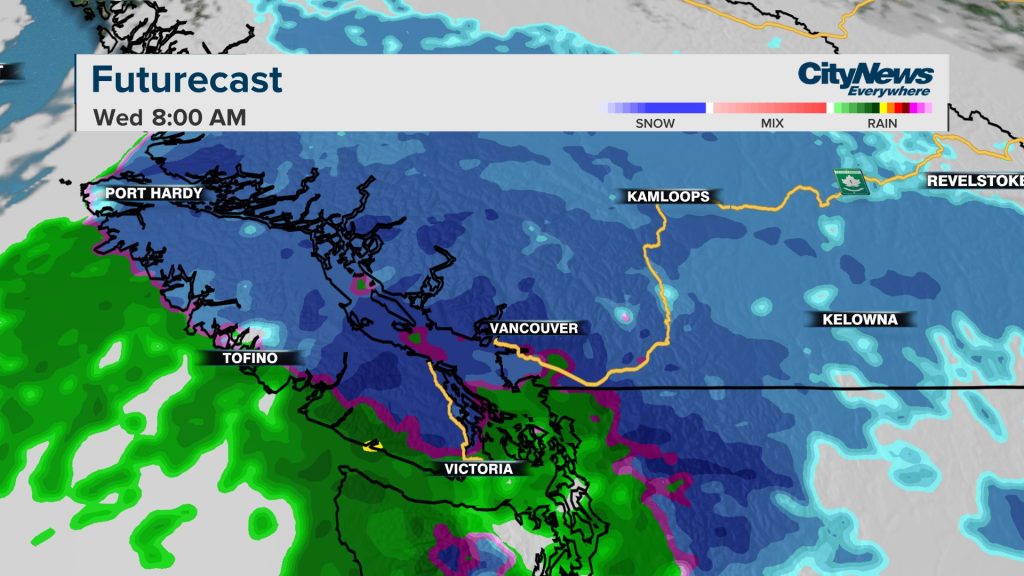
It will be less shivering and more shovelling over the next 24 hours for B.C.’s South Coast as temperatures warm up and the latest winter storm sweeps in, bringing the threat of significant snowfall late Tuesday evening through Wednesday morning.
Environment and Climate Change Canada (ECCC) issued a warning early Tuesday for Metro Vancouver, the western Fraser Valley, the Sea-to-Sky corridor and much of Vancouver Island, saying the expectant low-pressure system will bring “widespread snow.”
“The precipitation starts late evening — we’re expecting that wet weather to slide in near midnight starting as mixed precipitation turning over to snow through the overnight,” said CityNews Meteorologist Michael Kuss.
“There will be heavy bands of snow for most of the area but mixed precipitation right along the coast with some of that warmer air just permeating the western parts of the Lower Mainland.”
Kuss expects the heaviest snow through the Wednesday morning commute.
“It looks like in a window between 5 a.m. and 9 a.m. and then tapering off late in the morning, so the morning drive isn’t going to be a good one.”
“There’s still going to be snow around as the road crews work away into the afternoon. Away from the water, 15 to 20 centimetres of snow is not out of the question,” Kuss explained.
In a statement issued Monday evening, the province’s Ministry of Transportation and Infrastructure says its maintenance crews are preparing for the weather in Metro Vancouver, the Fraser Valley and Vancouver Island.
“We have heavy tow equipment in place at key areas such as major bridges in the Lower Mainland,” said Rob Fleming, minister of transportation and infrastructure.
Cable collar systems, which are used to clear snow and ice on the Port Mann and Alex Fraser bridges, will also go into operation if necessary.
“We have the technology in place, but it’s very manual. You need to have skilled people who go up for a job that you and I probably wouldn’t want to do, which is scaling those cables and basically breaking off ice accumulations,” Fleming told CityNews.
“We pre-position those to be in place and have data that shows how much is accumulating. When it reaches a threshold where it needs to be cleared, we do that as quickly as possible, making any temporary lane closures that are needed so that none of it falls on cars.”
The province is urging people to try to avoid travelling by vehicle Tuesday evening and into Wednesday morning if conditions get bad.
It adds that bridges and roads may be closed to traffic for safety if the weather requires it.
ECCC adds there is a risk of freezing rain Tuesday night near southern sections of the coast near the United States border.
Listen to CityNews 1130 for weather updates after traffic every 10 minutes on the ones. You can also follow Meteorologist Michael Kuss on X and subscribe to breaking news alerts sent directly to your inbox.
–With files from Pippa Norman and Charlie Carey


