Hope prepares for surge of debris-laden water from Chilcotin River landslide
Posted August 6, 2024 3:34 pm.
Last Updated August 6, 2024 10:40 pm.
The B.C. government says the risk of a worst-case scenario has drastically decreased, but it’s keeping a close eye on river flows as a “big pulse” of debris and sediment-laden water works its way down the Fraser River after a massive landslide dammed the Chilcotin River last week.
The province’s water management branch says the pulse of water after the dam breached Monday morning is making its way down the Fraser River toward Hope.
At a press event Tuesday afternoon, Connie Chapman, the executive director of water management with the Ministry of Water, Land, and Resource Stewardship, said the ministry is continuing to monitor as water flows through the landslide dam. She says the reservoir that was formed behind the natural dam is currently decreasing at a rate of roughly 2.5 meters per hour.
Chapman says the province’s current prediction models show that a peak flow of the water surge is expected to reach Hope at midnight Tuesday.
At peak, the water on the Fraser River at Hope is predicted to be 80 centimetres higher than typical.
Mayor of Hope Victor Smith tells CityNews that his district is prepared for the coming surge, but he expects to be cleaning debris into the winter season.
“What’s going to happen is the surge will come … we’ll get about a metre of water, and then when it drops, unfortunately, some of the debris is going to be on the bank. So come next spring, all the debris that’s left on the whole pathway is going to be coming down here, which will create a bit of a boating hazard,” said Smith.
He says since the surge is unlikely to reach the annual high-water mark, no local properties are being evacuated, but he asks that Hope residents still act safely around the river.
“Please don’t be standing near the bank to get that perfect picture. Go someplace higher and get your camera to zoom in instead of walking down there,” said Smith.
“Just don’t be down near the river’s edge.”
Upstream in Lytton, Chapman says water will reach a peak height of 2.2 metres above its starting point Tuesday afternoon. Boston Bar is expected to see 1.8 metres of water above current levels by 7 p.m. Tuesday.
“What we are really looking for is watching that pulse of water move through the system, looking for where debris is settling out, and understanding where the debris may have been. caught up and hung onto it, just for safety purposes.” said Chapman.
Debris, erosion pose greatest remaining risk after Chilcotin River landslide: B.C. gov’t
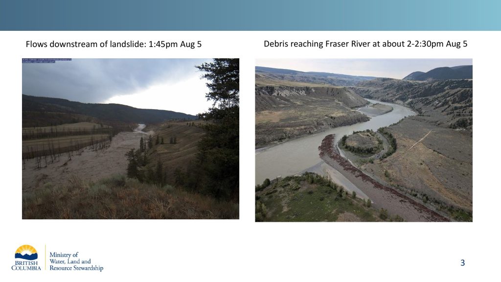
Chapman says the amount of flowing debris is presently the greatest danger, but it’s less concerning than before.
“Current flyovers have indicated that the flows that are currently flowing through the Chilcotin River and into the Fraser River have a reduced amount of large woody debris, and the amount of debris that is actually being witnessed within the flow is sediment, which is a positive,” said Chapman.
Samantha Wilbur, a senior regional manager in the Ministry of Emergency Management and Climate Readiness, says the Fraser River Debris Trap near Agassiz is also prepared to help reduce the risk. She says it’s operational and at less than 50 per cent capacity so far.
“We are monitoring, of course, as the water is rising, and keeping an eye on the debris that is coming down. We are confident right now that if the water does come up over one more meter, the debris trap will continue to do its job and trap that three as it comes in. And we also have excavators on standby to help remove some of that debris when it’s safe to do so,” said Wilbur.
Chapman says there is also a risk of more landslides along the Chilcotin River with the erosion caused by the surge, adding “undercutting of the banks” has been observed, but the ministry needs water levels to return to normal to complete a full scope assessment of the risk.
“There have been visuals, while flying over the last 24 hours, of small slumping events happening as the water has been flowing through. So there is most definitely that risk,” said Chapman.
“When you look at this landscape in the bigger picture, it is evident that slides are part of its natural cycle, and so it’s one thing that we will have to take into consideration and continue watching — just with the different composition of the sediment that is there and the landscape geology.
—With files from Charlie Carey and Cecilia Hua