B.C. Storm: Atmospheric river to ease Sunday, but rainfall warnings remain in effect
Posted October 20, 2024 9:56 am.
Last Updated October 20, 2024 1:34 pm.
The South Coast storm is expected to ease Sunday, but rainfall warnings are still active for much of the region.
Rain, wind, and flash flooding were seen across the Lower Mainland Saturday, with some municipalities seeing even more rain than was expected.
“We were expecting this to be 100-millimetre rainfall event, and for many areas, it’s well above that,” said 1130 NewsRadio meteorologist Michael Kuss.
“Even farther to the south, around Richmond, saw 100 mm of rain. But out of the North Shore, it’s been 150-plus. Tri Cities are 150 to, in some pockets, over 200 mm of rain, and that was just at 6 a.m. Sunday morning with more rain to come.”
Environment Canada says around 15 to 25 millimetres of rain are expected around the Vancouver area Sunday, with a tapering off in the evening.
The BC River Forecast Center has a flood watch for the entire South Coast. The Coquitlam River and parts of West Vancouver Island – including rivers around Tofino, Bamfield, Port Renfrew, and surrounding areas – are under a flood warning.
Rain around the region had already broken records on Thursday. An all-time rainfall record for 24 hours is expected for Langley, another record at YVR, and other notable amounts in several municipalities.
“Over 100 mm at YVR — record setting precipitation on Saturday. West Vancouver, 177 mm, even in the harbor, 150 mm downtown Vancouver, with Pitt meadows, 140 mm,” Kuss said.
“What has made this atmospheric river, this event, so severe, so damaging, is not just the intensity, but often these systems meander around a little bit. So the precipitation isn’t steady for such a long period of time, they will oscillate, move slightly north, slightly south. But this one had a bull’s eye — the hose focused right on the Lower Mainland and across the South Coast for such an extended period of time.”
The atmospheric river has already done a lot of damage, and it isn’t clear what comes next.
The North Shore was overwhelmed with rain and floodwater Saturday as the atmospheric river continued across coastal B.C.
In the hillsides of West Vancouver, rivers could be seen running through the streets, prompting several road closures.
Videos posted to social media show Deep Cove and other parts of North Vancouver with flooded streets, homes, and businesses.
Heather with Deep Cove Collective – a store and ice cream shop – says the business was partially flooded.
“We started blocking it up with wood and shelves,” she said.
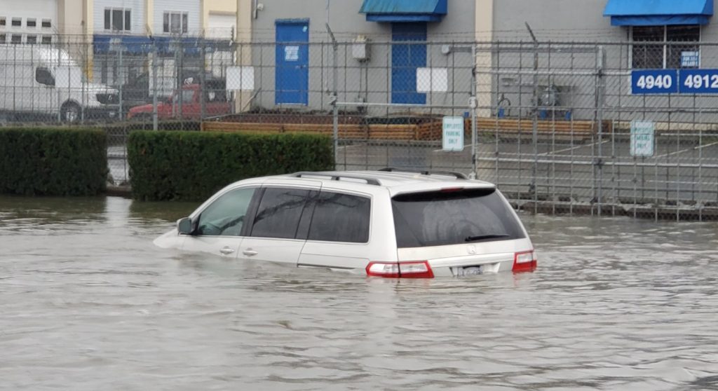
In Burnaby, cars and at least one bus were seen submerged in water in the the Still Creek area.
City engineers say the area is prone to flooding, but this was extreme.
“It is probably the worst flooding we have seen in years,” said Brian Carter, director of public Works for the City of Burnaby.
“For the maintenance, it goes through Still Creek, which is controlled by a dam at Cariboo, and there is only so much water that can be going through there at a time.”
Out in Surrey, there were closures due to flooding on King George Highway and on 152nd between 72nd and 82 Avenues, with some areas under a foot of water.
Engineers in the city are hopeful the water would subside.
“We will continue to monitor it as the tides are low in the early morning. The tides are going to be on the low side and help drain the water back to the ocean, and that will allow us to reopen the roads,” said City of Surrey director of engineering operations Yonatan Yohannes.
“The magnitude of it is a one in 50-year event.”
Meanwhile, Coquitlam Search and Rescue crews were called out to save a trio of hikers stranded off Burke Mountain and to rig up a series of ropes to ferry the hikers across a creek that had exploded into a raging river.
With files from Angela Bower and Charles Brockman.