River surges may impact Lower Fraser with flooding this weekend
Posted July 3, 2020 6:55 am.
Last Updated July 3, 2020 7:01 am.
VANCOUVER (NEWS 1130) — Heavy, sustained rains have left most of B.C.’s northern, central and eastern interior under flood warnings, flood watches and high streamflow advisories.
“The Upper Fraser River is expected to reach between a 20-50 year flood level and possibly beyond on July 4th,” according to the provincial flood status update.
With more rain in the forecast the province is warning surges could make their way into the Lower Fraser River Basin, bringing renewed risks of flooding in the Lower Mainland.
The province is asking anyone who lives near the river or in low-lying areas to be vigilant and stay apprised of emergency updates in the coming days, including those between Hope and the Pacific Ocean.
Trans Canada Highway closed
So far, flooding has been limited and localized but two separate incidents have closed Highway 1 on either side of Revelstoke.
Drone photos of the flooding situation on #BCHwy1 west of #Revelstoke. Road still closed. Estimated time of opening not available. Detour not available. Work in progress. Probability of opening tonight is low. Next update Fri Jul 3 at 5 AM PDT: https://t.co/xejCLgbIF8@DriveBC pic.twitter.com/WTmCeyFEnK
— Rocky Mountain District (@TranBCRockyMtn) July 3, 2020
The first breach caused a closure about 15 kilometres west of town just after 8 a.m., Thursday and by 9 p.m. a second breach caused another closure to the east, between Golden and Revelstoke.
According to Drive BC, the Upper Arrow Lakes Ferry, on Highway 23 south of Revelstoke, had hours-long waits and would be running through the night to accommodate travellers in need of a detour.
A truck driver who says he was the last one through before the highway was closed posted a video of the flooding online.
The Revelstoke region remains under a high streamflow advisory while other regions, including the Upper Fraser River and all tributaries to Prince George are under flood warnings or flood watches.
A high streamflow advisory means levels are rising or expected to rise rapidly, but no major flooding is expected while minor flooding in low-lying areas is possible. Flood watch means river levels are rising and will likely approach or overflow at the banks, while flooding of areas adjacent to affected rivers may occur.
Flood Warning is the highest hazard rating and means “river levels have exceeded bankfull or will exceed bankfull imminently. Flooding of areas adjacent to the rivers affected will result.”
The province is also warning about potential record-high flows along a number of other rivers.
“The Quesnel River is forecast to reach a 50-year flow on July 5-6, possibly even exceeding record levels from 1972. The North Thompson River is forecast to reach close to a 20- year flow July 3rd-4th while the South Thompson River may peak at a 10- year return period flow. Other notable flood forecasts today include the Seymour River near Seymour Arm (likely peaking on July 2nd), and the Fontas and Muskwa Rivers near Fort Nelson peaking July 3rd-4th,” details the flood status update.
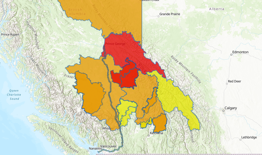
With much of the province under flood warnings, the Lower Fraser River is expected to see surging waters in the coming days. (Courtesy B.C. River Forecast Centre)
The River Forecast Centre says rainfall amounts in the last 48 hours have ranged from 40-80 millimetres in northeast B.C., and 25-60 mm in the Prince George, Robson Valley, north Thompson, north Shuswap, and Cariboo Mountain regions.
“Next week’s forecasts generally show unsettled weather with the potential for more rain and localized thunderstorms across much of the province, due to a massive cold trough with rotating lows that extends from Vancouver Island all the way to NW Alberta.”
The Forecast Centre also says the risk of snowmelt freshet has subsided significantly as the majority of the province’s snowpack has now melted, and the final snowmelt bulletin was released in mid-June.


