Dangerous cold continues in B.C. as several areas break temperatures records
Posted December 28, 2021 6:55 am.
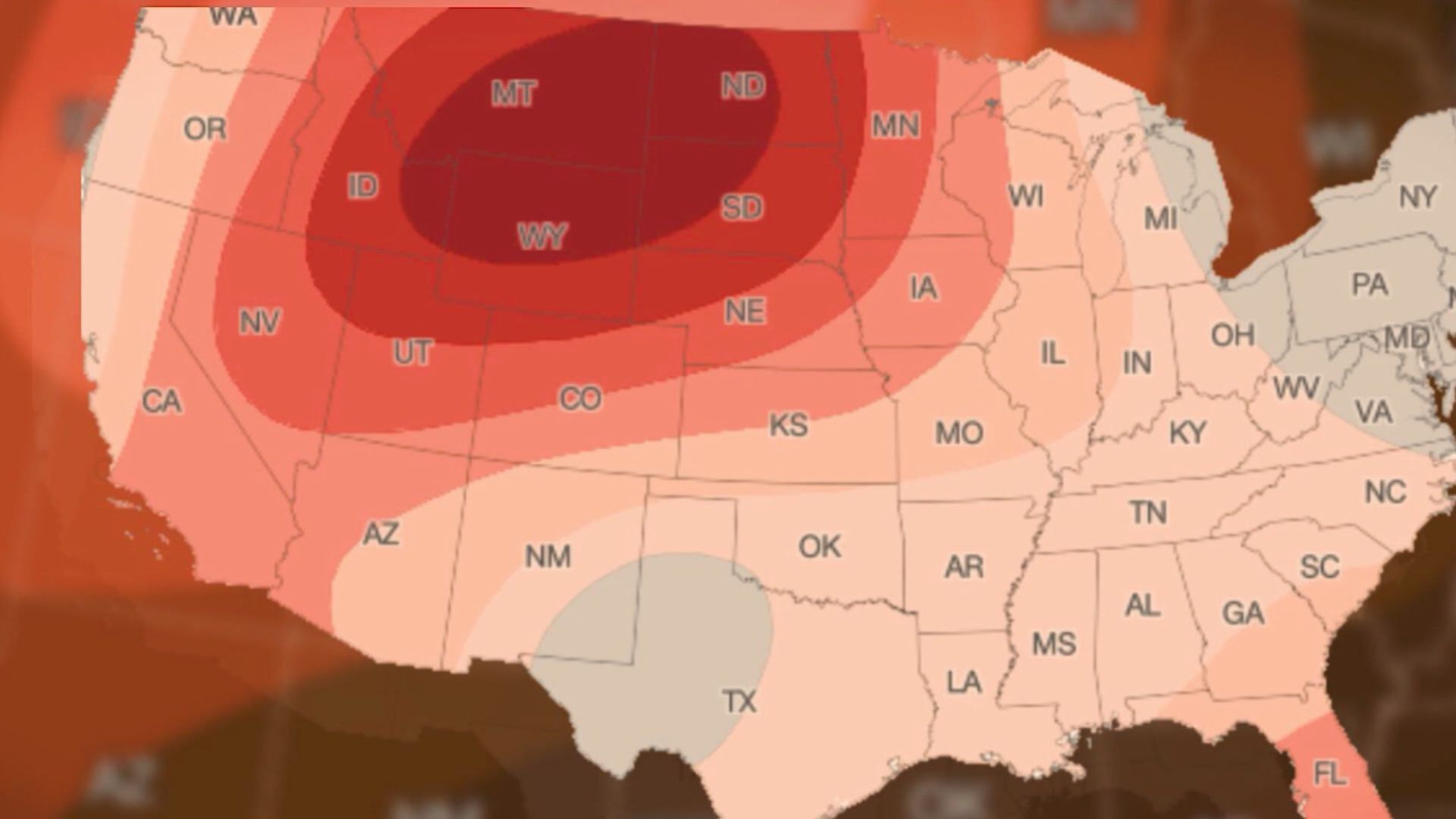
Metro Vancouver, the Fraser Valley, as well as most of Western Canada remain under extreme cold warnings on Tuesday.
The arctic outflow conditions that have caused temperatures to plunge have not moved on yet, although there is some hope on the horizon.
Until that happens, however, people are urged to be prepared if heading outside and to be cautious on the icy roads.
Related Articles:
-
Life-threatening cold leading many to seek warmth at homeless shelters
-
B.C.’s South Coast in a deep freeze until Wednesday
-
Body of snowboarder found after search on Big White in Kelowna
The temperature at Vancouver International Airport on Tuesday morning at 5 a.m. was reported at -12 C but with the wind chill it felt more like -20 C.
Although the overnight cold is well below the average temperature of 5 C, it’s not close to the record set on Dec. 28 in 1968 at -16.1 C.
There were nearly a dozen records broken on Monday.
“We’ve broken some records in the B.C. Coast that have been set back in the 1800s,” CityNews Weather Specialist Denise Andreacchi said Tuesday.
The record breakers include: Abbotsford, Agassiz, Bella Bella, Clinton, Gibsons, Hope, the Malahat area, Osoyoos, Penticton, Port Alberni, Port Hardy, Powell River, Sechelt, Sparwood, Squamish, Vancouver, and White Rock.
While Vancouverites were cold, those living in Quesnel were even colder. The city in the Cariboo region set an all-time record with -38.9 C on Monday.
Andreacchi says there is a concern for health and safety when temperatures drop that low.
Watch for symptoms of shortness of breath, chest pain, muscle pain and weakness, as well as numbness and colour change in fingers and toes. Officials are urging everyone to check on their loved ones and to keep pets indoors.
Several extreme weather shelters have opened in recent days to ensure those who don’t have a home have a warm place to stay.
In response to the extreme cold weather the City of Vancouver is extending the current alert beyond Dec 27. Warming centres remain open & we encourage anyone who is sleeping outside or out in the cold during the day to visit one of these centres ➡️https://t.co/5rI5BVPYgd pic.twitter.com/51EHicyPpH
— City of Vancouver (@CityofVancouver) December 27, 2021
For a list of shelters in B.C. click here.
“They will continue tonight to see windchills close to – 20 C. This will continue into Wednesday and Thursday as well. Bitterly cold temperatures of course can result in frostbite and hypothermia,” Andreacchi said.
She adds the biggest concern is the wind, with gusts remaining strong overnight until Wednesday, bringing that arctic blast along with it.
The snow isn’t going away anytime soon either.
The forecast calls for more flakes Wednesday night and into Thursday. On Friday and Saturday (New Year’s Eve and New Year’s Day) even more snow is expected.
Environment and Climate Change Canada says it will warm up beyond Wednesday, but those in Vancouver shouldn’t expect to put away the gloves until after the weekend when temperatures will return to more seasonal numbers.