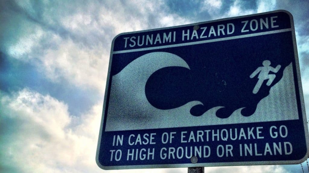
What to do if a tsunami hits B.C. coast
Posted April 11, 2022 7:18 am.
Last Updated April 11, 2022 7:20 am.
If a tsunami were to hit the B.C. coast, would you know what to do?
Tsunami Preparedness Week is meant to help educate British Columbians about the risk of such events on our coastal communities, though Parliamentary Secretary for Emergency Preparedness Jennifer Rice notes they are “rare.”
This week is Tsunami Preparedness Week! While rare, tsunamis are a real threat to #BC’s coast, so it’s critical to be prepared.
Learn how: https://t.co/fKmdHgLTRJ
#TsunamiPreparednessWeek#PreparedBC pic.twitter.com/O6Qjoxx2tq— Jennifer Rice (@JenniferRice6) April 10, 2022
B.C. is a seismically active area, with many communities on the shoreline at risk should a tsunami take form. Tsunamis are most often caused by undersea earthquakes or even volcanic eruptions which, in turn, trigger large waves.
The last major tsunami in B.C. was the one to flood Port Alberni in March of 1964. It came after a 9.2 magnitude earthquake hit Anchorage, later becoming known as the Great Alaskan Earthquake.
Tsunami Zones
In the province, coastal communities are divided into five notification zones.
The first, Zone A, includes the north coast and Haida Gwaii, while the second, Zone B, includes the central coast and the northeast Vancouver Island coast, including Kitimat, Bella Coola, and Port Hardy. Zone C covers the west coast of Vancouver Island from Cape Scott to Port Renfrew, while Zone D encompasses the Juan de Fuca Strait from Jordan River to Greater Victoria. Finally, Zone E covers the Strait of Georgia, including the Gulf Islands, as well as Greater Vancouver and Johnstone Straight.

B.C.’s tsunami zone map. (Courtesy B.C. government)
People are asked to check in with their local authority to find out what their community’s tsunami plan, evacuation routes, and high ground locations are.
British Columbians are reminded that tsunami warnings will be broadcast across TV, radio, and compatible mobile devices through the Alert Ready system, which is tested twice a year.
Some communities may also have their own alerting system, including sirens.
Tsunami alerts
In addition to knowing what zone you live in, British Columbians are encouraged to learn about the different types of alerts issued by emergency authorities.
The most severe is a tsunami warning, which identifies a flood wave is possible and that full evacuations are suggested.
A tsunami advisory suggests strong currents are likely and that people should stay away from the shore.
A tsunami watch suggests the danger level isn’t known yet and that people should stay tuned for more information.
An information statement means officials are expecting “minor waves at most,” adding “no action” is suggested, while a cancellation means tidal gauges have shown no activity.
It’s also crucial that residents have grab-and-go bags for each member of their household and that they’re accessible.
What to do if you feel an earthquake
Once again, people living near the coast should be aware of what their community’s tsunami/earthquake plan is. If you are near the coast in an area without evacuation maps, plans, or cell service, and feel an earthquake, it’s recommended you move to at least 20 metres above sea level right away.
You should never head to the beach in such a situation, with experts noting a tsunami can come up quickly and move faster than you can run. You are urged to move to higher ground and wait for the all-clear before heading back. Always follow your community’s evacuation plans if they have them.
High Ground Hike is a campaign that aims to raise awareness and help people know what to do in the event of a tsunami during Tsunami Preparedness Week.
During the week, the province is asking British Columbians to learn more about their area’s tsunami plans and to practice getting to tsunami-safe locations with your friends and family.