Flood and fire concerns spread across B.C.
Posted May 1, 2023 6:59 am.
Last Updated May 1, 2023 9:37 am.
The first day of May brings with it some serious concerns about the flood and wildfire situation in British Columbia — a sure sign spring is in full swing.
More than two dozen new fires, most of them small, have popped up in just the last 10 days.
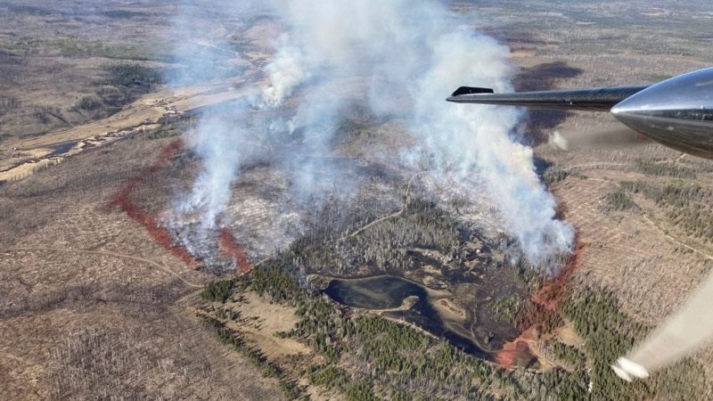
Two are deemed out of control right now in the Cariboo.
The B.C. Wildfire Service says the Dripping Water wildfire has grown to more than 200 hectares, putting people on evacuation alert. Northwest of Kamloops, the Lost Valley wildfire is burning at more than 100 hectares. The service says both are believed to have been sparked by people.
Related Articles:
-
Dripping Water, Lost Valley wildfires prompt evacuation alerts in Cariboo region
-
B.C. wildfire season underway with fire near Ashcroft
-
B.C. prepares for spring floods, summer wildfires
“Aside from July and August, spring can be the most dangerous for wildfires,” explained CityNews Meteorologist Michael Kuss. “What we see this time of year is the snow, which has melted already, but most of the vegetation is still dormant, so there’s no moisture in that vegetation and what that results in is tinder-dry conditions.”
He says in the short term, temperatures are going to be around or above seasonal for the entire province.
“The big story will be the continued, dry weather. There’s a blip of precipitation in there by the end of the week, not just along the coast, but inland too but after that, it dries right out. That combined with the already tinder-dry conditions around the province [is] definitely not helping the forest fire situation,” added Kuss.
Both fires have triggered evacuation alerts for nearby communities, where officials are recommending that residents plan escape routes, secure emergency accommodations, and be ready to leave on short notice.
Meanwhile, the rising water levels brought on by the recent warmer weather we’ve experienced have triggered a number of flood watches and advisories around the province.
The Village of Cache Creek has issued an evacuation order for a single property along Highway 1 due to an “existing or imminent” threat of flooding.
The province has issued high streamflow advisories in the east and west Kootenay, Kettle, and Granby rivers’ tributaries, as well as the Upper and Middle Fraser regions and the South Interior, while a flood watch also remains in place for the Lower Thompson and Nazko rivers.
“We have an above normal snowpack and that’s across the entire province and as soon as you get incredibly warm air, that means a massive run-off and a melt and that’s what we’re seeing.
“Over the next handful of days, temperatures will cool but not dramatically, so we are going to see a rise in those rivers and streams — not sure, at this point, if it’s too a dangerous and widespread flooding level yet,” said Kuss.
He warns run-off amounts will increase in the coming weeks as all the snow in the mountains starts to trickle down.
B.C. temperature records broken
The summer-like conditions over the weekend ended up in some temperature records in B.C. being broken.
According to Environment and Climate Change Canada, 15 different communities set new marks on Saturday.
Places like Pemberton, Cache Creek, and Kamloops all topped 30 C°, beating previous records by at least two degrees.
It was a similar story on Friday, with a dozen B.C. communities also seeing temperature records fall.
On Sunday, another five regions saw record-setting mercury levels. They include areas surrounding Blue River, Golden, Vernon, Williams Lake, and Yoho National Park.
–With files from Dean Recksiedler and The Canadian Press